Bathymetric data and simultaneously side scan sonar data shall be acquired using a high precision multi frequency Geo Swath multi beam echo sounder.
The mobile DGPS Receiver will interface to the GEO SWATH multi beam echo sounder. The Geo Swath processor receives the depth data and time,
synchronized with the GPS position. Thus position and depth data along with date, time will log on the hard disk at one-second intervals. The Geo Swath Sonar transducer array shall be mounted on a pole mount over the bow of the vessel. The DGPS antenna shall be mounted on top of the transducer pole, directly above the Geo Swath ‘V’ plate, to reduce lever arm offsets. Geo Swath 250kHz transducers, the MRU, the Precision Altimeter and the Mini SVS is mounted on the ‘V’ Plate. The SG Brown Gyro compass will be secured aligned with the vessel centerline and SVP dips shall be taken as required.
The Geo Swath software allows coverage to be monitored in real time, and
several data displays are available for the surveyor to maintain a high level of data quality control.
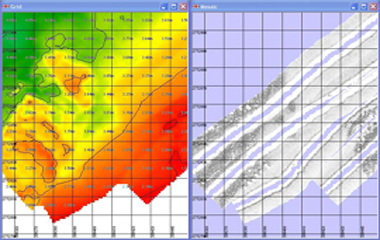
The Geo Swath is supplied with a complete set of software for data collection; calibration, filtering, generation of digital elevation models (DEMs) and side scan mosaics. Data quality control and data visualization tools are an important part of
the package. Raw swath data was filtered to remove outliers, sound velocity corrections, tidal corrections were applied and navigation data was checked and edited using the Geo Swath Swath32 software. The calibration parameters is applied to the filtered swath data, giving geo referenced, calibrated data files on a line-by-line basis.
The speed of sound is measured in the beginning and ends of the work by
deploying a CTD valeprot 600.